
A bit of Everglades History and locations from Wood’s Revenge
The once pristine Everglades are riddled with man-made features. Many were used in my latest book: Wood’s Revenge. Both testing stations and the maze of dredged canals criss-crossing the River of Grass are used for locations and in the development of the premise for the book.
Testing stations monitored by the Florida Coastal Everglades LTER (Long term ecological research network) were established by the National Science Foundation in 1980. Their purpose is to monitor the water quality and flow from Shark River and Taylor Slough, two of the Everglades’s primary drainages. The Taylor Slough testing sites labeled TS/ph(#) are the ones Mac used to track down the source of the polluted water in Revenge. Starting out in Florida Bay by Sprigger Bank, TS/ph11, about thirty miles from Wood’s island, was the site where Mac found the wreck. He followed the string of test sites until they found themselves entering canal C111 otherwise known as the Aerojet Canal, built in the 1960s to move rocket engines to the now abandoned Aerojet facility. You can see all the locations and track his route on the map here.

The development of the Everglades and subsequently the canals were started after the Civil War by a developer named Hamilton Diston and continued through the late 1900s. With the original goal of draining the Everglades to create agricultural land, property values soon increased from 25 cents to five dollars per acre in the late 1800s making the land more viable for development. The lack of proper planning resulted in catostrophic flooding of many of the newly developed cities in the early 1900s, causing the Army Corp of Engineers to step in and construct the Herbert Hoover Dyke around Lake Okeechobee. More flooding and the population boom following World War II resulted in many of the canals and floodgates we still see and use today.
In all there are over a thousand miles of man-made dredged canals running like highways through the sawgrass. In 1948, a hundred mile canal and berm located at the western edge of Palm Beach and Broward counties was built. Know as C-38, this is the canal that Mac uses to reach Clewiston, home of the fictional Dusharde Sugar.
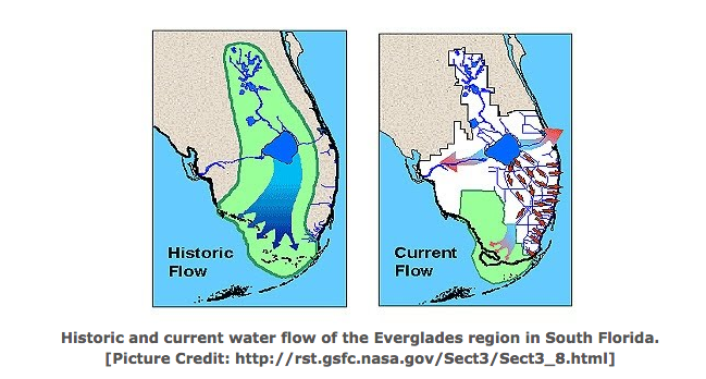
These dykes, berms, and canals altered the Everglades, forcing most of the water from the Kissimmee drainage and Lake Okeechobee to be rerouted to the east and west coasts. Rather than allowing the water to flow naturally, using the Everglades as a filter system before bringing the water to Florida Bay, the fertilizer laden water reaches the Gulf of Mexico and Atlantic Ocean. The result of this are fish kills and red tides as well as an increase in the salinity of Florida Bay.


I appreciate the history lesson. Interesting to learn the facts about the area
LikeLike
Awesome history!
LikeLike