Mac Travis Adventures: Book Six
SPECIAL RELEASE DAY PROMOTION
ONLY 99c
(Reverts to the normal price of $4.99 after today)
 Desperate for money and with Alicia in danger, Mac is forced to deal with a dubious antiquities dealer. The treasure hunt turns deadly as he tries to solve the riddle of the relic he found years ago.
Experience the counter-culture and adventure of the Florida Keys in this new adventure by best-selling author Steven Becker.
Available on Kindle

 Many of the islands that make up the Florida Keys are popular tourist spots, including Bahia Honda. It can be found in the Lower Florida Keys and even though it has no permanent residents, the island is home to the 524 acre Bahia Honda State Park. Founded in 1961, the park extends over most of the island and is known for its breath-taking beaches and excellent snorkelling.
The Overseas Railroad was built as an extension of the Florida East Coast Railroad to Key West, and operated from 1912-1935. As a part of this project, The Bahia Honda Railroad Bridge was built in order to connect Bahia Honda and Spanish Harbor Keys. It was constructed by William Krome and Joseph Meredith, and the entire Overseas Railroad was funded by Henry Flagler. The rest of the project was designed with a concrete arch but because of the additional depth of the Bahia Honda channel, which is 24ft at its deepest point, this section of the bridge was built with a steel truss construction.
In 1935 much of the line was destroyed in a fire and the Florida East Coast planned to abandon most of the Overseas Railroad, including the bridge. It was purchased by the State of Florida, however, and converted into a highway in 1938. The lower level of the bridge was too narrow to accommodate two lanes, so this was accomplished by re-decking the top for the vehicular traffic. At the time, this became the primary way for visitors to access The Lower Keys, as well an evacuation route from the area.
 In 1980 a four-lane bridge was built a hundred yards north of the original, which replaced the main route to the island. At a later date, two truss spans of the old bridge were also removed to allow boat traffic to pass. This created a gap in the bridge which many people find quite scary when walking along it. Recent visitors to the original bridge will have noticed that it is in a state of disrepair, with several warning signs about the possible danger from falling debris.
Despite the condition that the bridge is in The Bahia State Park does its best to maintain it, and on the Eastern most section it is possible for tourists to get a scenic view of the area. On a clear day sea turtles, several species of fish as well as large rays can all be seen swimming below. There are also many adventurers who get a thrill from diving off of the bridge into the sea. This is a popular pastime in Florida where the water is warm and inviting, and is called bridge diving.
Known as a fish watcher’s paradise, the coasts of the 1700 islands that make up the Florida Keys are full of mangroves, corals, reefs and wrecked ships. These provide the perfect homes for many fish, and other animals, that are attracted to the appeal of the area. The animals that reside in these waters are friendlier than in most other places, because of the conservation of the corals. Some of the creatures that can be spotted on a dive here are:
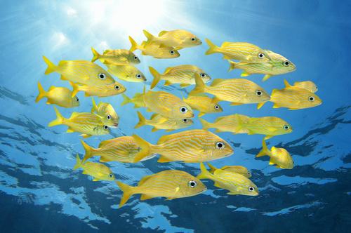 Grunt – The blue-striped grunt is the icon of the Florida Keys and large schools live in and around the coral reefs. Also visible are schools of French and small mouth grunt.
Barracuda – These fish are very popular in the area, and even though they normally travel alone, because of the safety of the waters, schools of them likely to swim by.
 Parrotfish – These fish sleep in mucus cocoons among the reefs, and are known to appraoch divers during the day.
Shark – Regardless of the fact that they are bigger than the other fish, the sharks in the Florida Keys are very reluctant to go close to humans. This doesn’t mean that they don’t reside in the waters, however. Tiger, bull and hammerhead sharks can be glimpsed hunting among the large schools of fish which pass by. In addition, there is the occasional spotting of a great white shark in the deep water pinnacles between a few of the islands.
Eels – Even though eels are normally unpredictable, many of those located in the Florida Keys are more sociable as a result of being fed by divers. Approaching one with a treat in hand is an activity that is unique to the area, and gives observers the chance to see them as closely as they dare.
Octopus – Among the other creatures that swim in the Keys, blanket octopus have been noticed swimming near the reefs. These are very rare and have never been officially photographed in the wild.
Jellyfish – Always one of the most interesting creatures to observe, jellyfish can be found in large amounts. Even though they rarely attack humans, their tentacles cause a painful rash when they brush against our skin. This is because their stinging cells release venom which is normally meant to either kill or paralyse prey, or protect the jellyfish from predators. Cassiopeia, moon jellies and cannonball jellies are all very common and have relatively mild stings which won’t affect most humans. Jellyfish larvae, also known as sea lice, cause a rash when they come into contact with the skin.
 West Indian Manatees – These large animals are mammals but live in the shallow, calm waters near the seagrass beds and other vegetation, especially during the winter when they migrate to warmer climates. They are very large and sometimes lethargic, because of this excess weight, so boats in the area need to be careful not to hit any of them when passing by.
Living in or around the Florida Keys represents a chance to get wet, wild and fit with the variety of water sports that are engaged in daily. Visitors also love and frequent this area as friendly locals, warm water and endless sunshine combine to make any holiday memorable. Regardless of age or skill level there will be several water activities that anyone visiting the Florida Keys can enjoy.
While all the traditional favourites such as snorkelling, surfing, and diving are regularly practiced, there are others that are even more adventurous and give a true example of what life on the coast can mean.
-
 Jet skiing – The best description for a jet ski would be a bike designed to be driven on water. Everyday people dare the waves and feel the breeze, as they use these bikes to manoeuvre around different obstacles such as coral reefs, rocks and small islands. Riding a jet ski well takes a lot of practice, as many unfortunate first timers learn when they get thrown off their bikes because of a need for speed.
 - Kayaking – Similar to canoeing, kayaking is done in long, low boats where the rower faces forward. A paddle with two blades is then used to propel the boat; as it is pulled front to back while alternating sides. Kayaks can be rowed by one or more persons, each with their own paddle to balance the craft.
- Water-Skiing – Not for the faint of heart, this sport requires a tow boat, a rope and one or two skis. The daredevil is pulled behind the boat, skimming the water while they try to maintain their balance on skis. This increases overall body strength and the sport is most frequently done in water that is both calm and deep.
- Knee-boarding – Bearing quite a few similarities to water-skiing, knee-boarding is a sport where a motorboat tows a person kneeling on a small surf-style board (with fins) instead of standing up. The person being towed sits back on their heels with an adjustable velcro strap on their thighs and hangs on to the tow rope. Knee-boarding has an easier learning curve than other towing water sports, and is also a favourite for beginners because of the person’s close proximity to the water.
 This means that in the case of a fall the impact will be significantly less, and the learner will be more likely to get back up and try again.
 - Windsurfing – This combination of surfing and sailing is done on a board which is powered by the sea’s breeze. In order to operate the sailboat, the surfer holds on and leans into the wind. Many advanced windsurfers can perform jumps, loops, and other tricks, the difficulty of which depends on individual skill levels and practice.


Other activities in the beautiful waters of the Florida Keys include ice-berg climbing, water trampolines as well as simply relaxing and enjoying the Florida sunshine.

Relic, the first book in the Mac Travis Adventures has now been revised, edited and extended to include an additional chapter at the end. Whilst I was at it I got the cover revamped whilst still retaining the original feel to the books. If you have the old version of Wood’s Relic (Pre June 2016) you can download the additional ending chapter by clicking here.
Wood’s Reef and Wall are also getting a revision and don’t forget book six, Wood’s Reach will be released in July.
The new version of Wood’s Relic is available in Kindle, Paperback and Audio Book

![]()
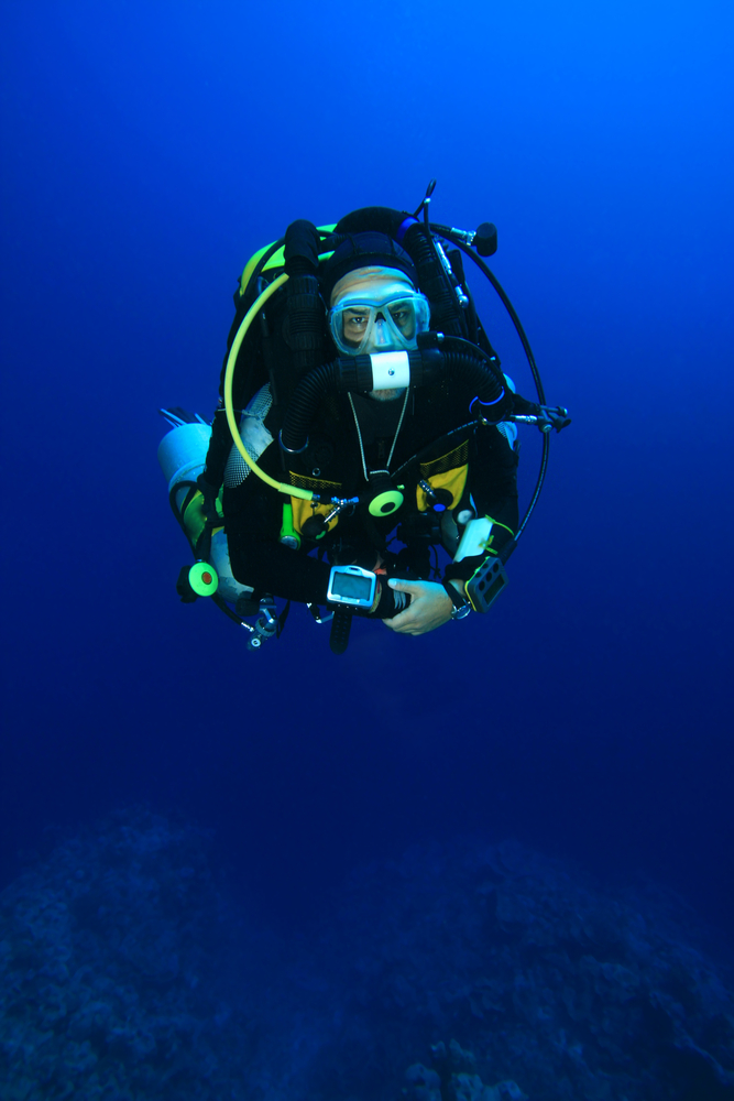
Deep sea diving always requires that there is enough gas to ensure a safe dive. The most common type of dive is one where a cylinder is filled with breathing gas and taken under. When this gas is finished the diver is required to resurface and refill or change the cylinder that they have. Using a rebreather eliminates the need to dive with an excess of gas. This is because it recirculates the air that the diver has already used, replacing his emitted carbon dioxide with oxygen in the correct amounts for breathing.
 Advantages of Rebreather Diving
- Long Dive Times
The only equipment that is needed is one filled cylinder and a carbon dioxide scrubber. This one fill can last anywhere between one and six hours, and be used for several dives. The length of time that the gas lasts is not affected by how deep the dive is, because rebreathers are designed to add gas for increased depth and take it away as the diver enters more shallow waters.
- Limited Bubbles
Regular diving cylinders produce many bubbles when the diver breathes. This can be disadvantageous as the bubbles alert the marine life to the divers approach, as well as fill small areas in wrecks with air and dislodge loose areas in caves. Rebreather diving is relatively silent and bubbles are normally only produced on ascent. This is one of the main reasons that marine biologists and photographers use rebreathers in their work and research.
- Warmer Air
As a result of the chemical reaction caused in removing carbon dioxide, the air that is produced by the rebreather is warm and moist. This helps to regulate the divers’ body temperature, as well as reduce the cotton mouth feeling that is caused by diving with regular cylinders.
- Optimum Air Mix
Rebreathers constantly monitor the air mix of the gas that is being taken in by the diver to ensure that it is ideal for humans.
 Disadvantages of Rebreathers
- Failure might not be Immediately Noticed
The most important part of keeping the gas breathable in a rebreather, is ensuring that the carbon dioxide is removed when the diver breathes out. When one fails it means that the division of air has become inappropriate for use. The only immediate indication of this will be shown on the equipment’s monitors, which the diver will need to be constantly paying attention to, as carbon dioxide and oxygen mixed in the wrong amounts can be fatal.
- Equipment
Rebreather equipment is normally bulkier and heavier than regular cylinders, and until divers get used to using it they may find that it is harder to operate and maintain. Higher quality equipment is also more expensive.
Originally used in military, scientific and technical dives the popularity of rebreather diving has extended to recreation because of the convenience of longer and quieter dives, and will probably keep doing so as more people begin to realize its benefits.
In 1733, the Spaniards were one of many European nations that were exploring, conquering and trading in the New World. Havana was the centre of Spanish commerce, at the time, and ships would use it as a port to rest and stock up on supplies before the long journey to Spain. On Friday 13th July, 1733 a fleet of 17 ships left Havana to undertake this voyage. The ships were led by El Rubi Segundo, a 60 cannon warship, which was under the command of Lieutenant-General Rodringo de Torres.
 There were two other large warships in the fleet, the Almiranta El Gallo Indiano and the Rufuerzo El Infante. All the ships, except the Royal Scoutship of His Majesty King Phillip VI, El Nuestro Senora del Populo, were packed to capacity with goods and provisions, both trading cargo and supplies for the crews, and armed to protect the fleet against piracy.
On the day after their departure, when the ships had arrived in the vicinity of the Florida Keys, the wind shifted abruptly and increased in velocity. The Lieutenant-General realized that a hurricane was approaching and ordered the fleet to return to Havana. He advised that they sail as close as possible to the wind to increase their chances of getting there. Unfortunately, his command was not given in time to save the majority of the ships and by the 15th of July many of them were either wrecked or sunk and much of their cargo lost.
After the storm, one of the vessels, Senor San Joseph aka El Africa, being completely unaware of the fate of the other ships stopped along the way to make repairs and went on to arrive in Spain safely. Four of the vessels made their way safely back to Havana. The survivors of the other 12 ships gathered in small groups on the surrounding islands, and built shelters from the debris that they were able to recover.
 The officials in Havana acted quickly and realizing that the fleet would have gotten caught in the hurricane, sent other vessels out to assess the loss and search for survivors. Shortly after, a small boat arrived in Havana and reported seeing a large ship grounded near ‘Head of the Martyrs.’ More rescuers were sent specifically to this area. In total 9 rescue vessels with supplies, divers and soldiers were dispatched to take care of the survivors, recover any cargo that they could find and protect it as best as they could. Any of the wrecks that were unable to float so that they could be towed to Havana, were burnt to the waterline to allow the divers immediate access.
Salvaging of the fleet’s cargo continued for years, and in an ironic turn of events after it was completed more gold and silver was recovered than had been originally listed as on board. The area was searched again in the 1960s and it is believed that most of the remaining wreckage was found, even though nobody could properly identify it.
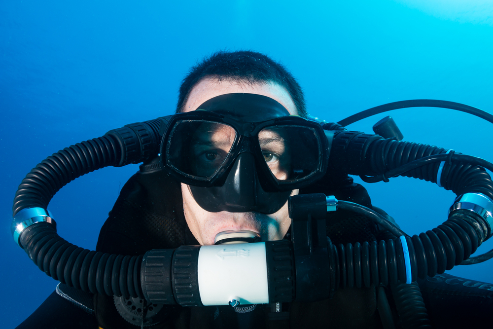
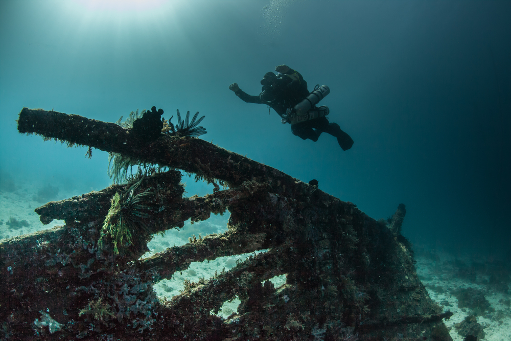
 When exploring beneath the sea, there are certain difficulties that a diver will need to overcome. The technique of sidemount diving was developed in order to make exploration of underwater caves and wrecks an easier process. This is because the cylinders are stored beside the divers, normally below their shoulders and along their hips, instead of on their backs. During a dive, two or more cylinders are attached in this way using bungee cord.
Advantages of Sidemount Diving
- Cylinders are more conveniently placed and accessible during dives.
This is especially useful when trying to get into smaller spaces, as the tanks can be removed and held in front of the diver while they squeeze through. Having them under the arms also means that they can block the majority of the water resistance that would normally be felt when diving. Divers are able to observe the cylinders constantly and be aware of the tank valves and regulators, and their position limits the amount of damage they receive. It also means that if a problem does arise it can be recognized quickly and solved as soon as possible.
- The cylinders are smaller and lighter.
This means that they are more easily transported and put on, especially in places with a limited amount of space. They are also more comfortable to wear, and can even be removed and replaced in the water.
Training for Sidemount Diving
There are three steps that need to be taken in order to become a certified sidemount diver:
- Recreational (Rec/Basic Sidemount)
This is the first stage where divers learn about the cylinders and other equipment. In order to move on they need to master adjusting, fitting and operating all of it, as this knowledge will be needed in the next stage.
- Technical (Tec/Tech Sidemount)
Stage two focuses on teaching technical decompression diving using three cylinders. Before starting level two, students will need to be certified as technical divers.
-
 Advanced (Overhead Cave/Wreck Sidemount)
This final level deals specifically with using sidemount diving to explore caves and wrecks. Students should be fully qualified in cave and/or wreck diving with lots of experience. They are then taught additional skills, which will be used specifically for handling demanding dives in these places. The main focus is to maximize using sidemount cylinders for confined areas.
Even though mainly used for cave diving and exploration, there is an increase in using sidemount diving for recreational and technical diving (recreational diving at a deeper level). This gives regular divers more freedom as they would normally have to rely on a diving partner to help change gear and monitor their regulators, but using a sidemount diving technique makes it possible for them to do it themselves.
Portolan charts were navigational maps designed to help sailors get safely to and from different places. The term derives from the Italian portolano meaning a collection of sailing directions. The first chart appeared in Italy during the 13th century, about the same time as the use of the magnetic compass, and countries such as Spain and Portugal began making their own shortly after. This new design of mapmaking meant that seafarers were now able to actively visualize Europe instead of just moving blindly from one point to another.
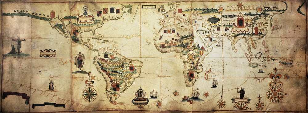 The portolan charts were about the size of a small coffee table and the first ones were accurate representations of the areas around the Mediterranean and Black Seas. They were designed using a network of lines in a circle, called rhumb lines, which showed the 16 directions of the compass. These were the maps skeleton, and created a foundation for the other details that were included. The maps illustrated specific coastal features, such as reefs and coastal islands, ports and their names, as well as the shapes of coves that the ships wouldn’t be able to enter. This was all valuable information to the crews when they needed to get to shore (to repair any damage or avoid dangers on the ocean).
 In the 15th and 16th centuries the charts were cartographically accurate, and they paved the way for the Age of Discovery and Exploration. With sailors exploring the seas further away, mapmakers could begin to create charts that showed areas as far as the African coast and the New World, based on the accounts that they brought back with them. The Age of Discovery was the same reason that their use declined, as topographers learned new ways of designing maps.
One of the major problems that mapmakers have, even today, is the fact that the earth is spherical while maps are flat, and they have to compromise and use various techniques in order to get a curved surface accurately represented on a flat one. Portolan charts showed how cartographers of the era were able to overcome this problem, as the maps are almost as accurate as the ones that we currently use. Mathematical skill was very influential in the way that they were created and the mapmakers capturing so many details using just the accounts of sailors was extremely unbelievable.
The oldest portolan chart that has been securely preserved can be found in the Library of Congress and has been dated between 1290 and 1350. There are very few that have survived to this century, and we can appreciate the remarkable feat accomplished in how these maps paved the way for discovery and expansion to mold the world in which we live in today.
Our society has become almost obsessed with passing on information. Even if it is not voluntary, it seems as if there is always somebody spying on another person. Whether it is your neighbour checking their home security system to see who comes to visit you, or the latest car crash being on YouTube hours before it hits the news. In this way it appears as if there is nothing that can be hidden.
 Appearances can be deceiving, however, because with all the new technology we are acquiring, and the constant threat of a terrorist attack, countries spying on each other has become more prevalent than ever. Even though espionage is often associated with war, this is not the only time that governments need to know what their enemies, or allies, are planning. The threat of war always exists and it is much better to be safe than sorry.
Like everything else in our modern society, the technological advancements dictate changes in the way that we might spy on each other. Much of the current espionage between countries is conducted remotely through the use of computers and satellites. In the US government system there are hundreds of thousands of cyberattacks each day, originating in Beijing alone. They are all attempts to get through firewalls, in order to learn the intelligence procedures that the government puts into place.
There is still a limit to what technology can do, however, and the need to have human spies in certain situations is always a requirement. Iran, North Korea and China probably have the highest number of spies in the US, and there are just as many (or more) from the US in their countries.
Jonathan Pollard, who was a US intelligence analyst, received a life in prison sentence for spying for Israel. This proved that countries can be allies but still feel the need to spy on the other. It was quite a bit of a shock to many of the nation’s citizens, but not entirely unexpected, since the US always has spies in Israel due to the threat of their supposedly secret nuclear project.
 Whereas government spies are expected and tolerated the biggest scare to the safety and security of the nation, is actually terrorist spies. Since they are not bound by either law, or in many cases, the same morals as everybody else they will do anything in order to achieve what they desire. One example of this is a double agent Al Qaeda spy in the CIA who committed a suicide bombing, killing several people and temporarily putting a hold on intelligence operations in Afghanistan.
As long as there are government systems, there will be spies from other countries trying to infiltrate them. The best way that it can be handled is to keep up with the technology, and other means necessary, to limit the information that they are actually able to pick up. This way the country and its citizens will be kept as safe as possible.